
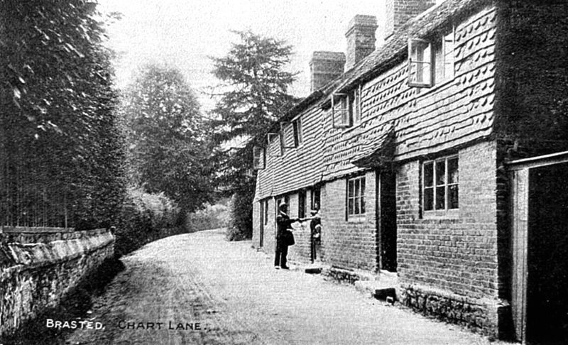
The top of Chart Lane, with its “unpicturesque string of workmen’s cottages”, just off Brasted High Street
David Lindsay’s posthumously-published novel The Violet Apple (1975) is mostly set in the Kent village of Brasted, in particular a small group of well-to-do houses along Malfait Street. While Brasted exists, Malfait (“ill-made”) Street does not, but it’s easy to identify with an actual road, given Lindsay’s descriptions of where the houses Croom, High Cot, and The Yellow House are situated. There’s even, intriguingly, a possible match for the ruined Halse Tower that provides a meeting place for the novel’s male and female protagonists, Anthony Kerr and Haidee Croyland, though it isn’t quite as Lindsay presents it.
Lindsay describes Brasted as a “little town straggled out on the main valley road between Riverhead and Westerham”,[1] this road being today’s A25, that runs south of, and parallel to, the southernmost section of the London Orbital Motorway, the M25 (built between 1973 and 1986). Brasted has only a few roads aside from its High Street (which forms part of the A25). Here is Malfait Street as Lindsay presents it:
“Malfait Street... consisted merely of an unpicturesque string of workmen’s cottages, with neither shops nor inn, and, still upwards towards the crest of the hill, a few good-class residences backing on the steep woodland dip separating them from the Ide Hill heights to the east... The road continued to ascend past the houses due south as far as the divide overlooking the Hever-Chiddingstone country...”
— The Violet Apple (1978, Sidgwick & Jackson), p. 32.
Ide Hill is an actual place, south-east of Brasted. And, as the ground rises generally south from Brasted’s High Street, it’s the south that can be taken as the direction of “upwards towards the crest of the hill” in Lindsay’s description. Malfait Street, then, comes south from Brasted High Street, with Ide Hill to its east. This — alongside its being the only road that goes south from Brasted High Street — means Malfait Street is most probably based on Chart Lane.
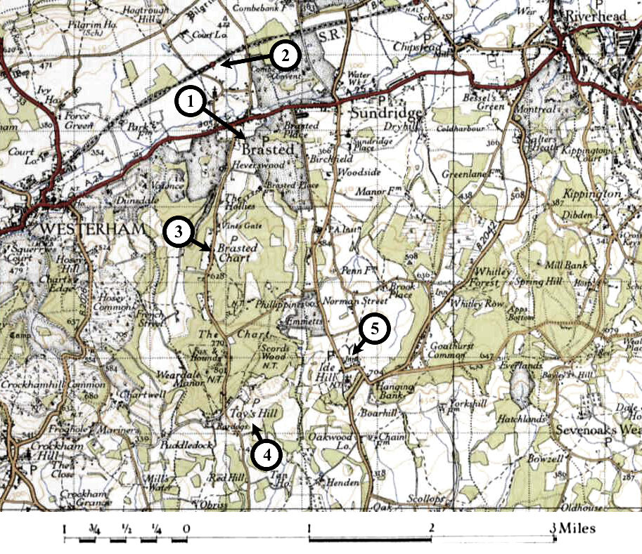
Brasted, from a 1945 map. Marked locations: (1) Brasted; (2) Brasted Station; (3) Chart Lane; (4) Toys Hill; (5) Ide Hill.
After leaving Brasted High Street, Chart Lane passes through the village of Brasted Chart, then comes to the hamlet of Toys Hill, which is due west of Ide Hill. Further south, both Ide and Toys Hill drop abruptly (from 248m above mean sea level to around 60m) into a three-mile-wide swathe of flat land before rising again at the towns of Hever (famous for its castle, where Anne Boleyn spent her childhood) and, to the east, Chiddingstone, just as Lindsay describes it.
(Visiting Toys Hill today, there’s a viewpoint, complete with a bench, providing a clear vista of this area of the country. The viewpoint is on the grounds of one of the first properties to be donated, in 1898, to the National Trust, and is named after the benefactor — also one of the three founders of the National Trust — Octavia Hill. The fact that her surname is “Hill”, and the property is on the edge of Toys Hill is mildly serendipitous, if perhaps a little confusing. As a side-note, another early supporter of the National Trust was Beatrix Potter who, if she visited the area, might have taken some inspiration for naming one of her characters from the road on which the viewpoint is found: Puddledock Lane.)
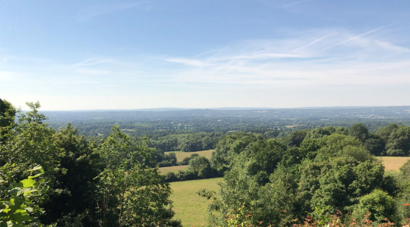
The view from the Octavia Hill viewpoint, on Toys Hill, looking south towards Hever.
How far along Chart Lane did Lindsay place Croom, High Cot, and The Yellow House? Later in the novel, Anthony returns to Brasted from London and walks “three miles”[2] from “the little country station” to his sisters’ house. The station no longer exists — it was demolished when the M25 was built, and would be under where the motorway is now — but it can be found on old maps, north of Brasted High Street. Anthony, then, would have walked down Station Road, then Church Lane, eastwards along the High Street, and then along Malfait Street/Chart Lane. Three miles by this route would take him to the hamlet of Toys Hill.
Although it’s impossible to place Croom any more precisely than this, it’s easy, on visiting the area, to imagine the house as Lindsay describes it, with a “sloping garden behind it... looking away towards Ide Hill, far across the wooded cleft”[3]. The current houses on Toys Hill are situated on the hill’s steep slopes, and between them and Ide Hill is the “wooded cleft” of Scords Wood.
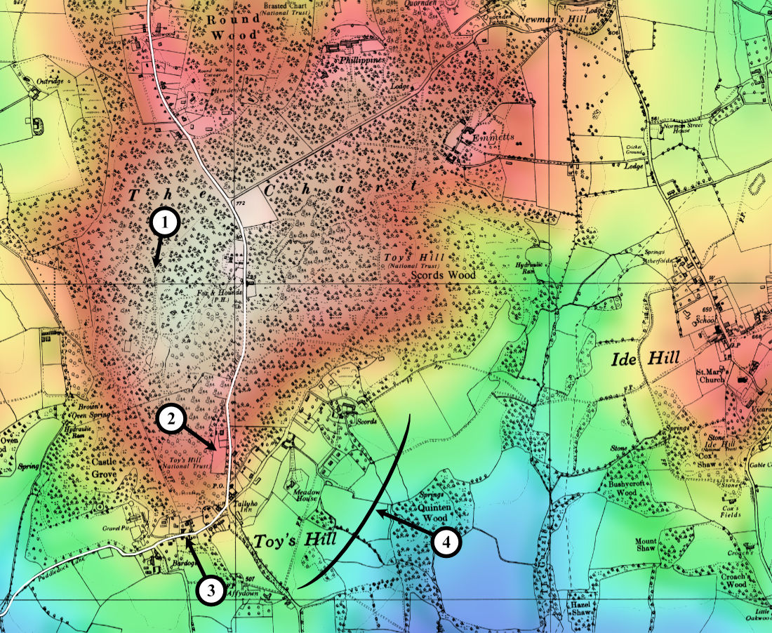
Elevation map of Toys Hill. Marked locations: (1) The Bat Tower; (2) Toys Hill Car Park; (3) Octavia Hill Viewpoint; (4) Houses facing Ide Hill.
Halse Tower
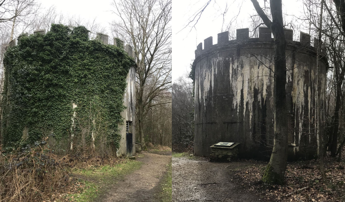
The Bat Tower.
In chapter 4 of The Violet Apple, Haidee Croyland meets Anthony Kerr at Halse Tower, a ruin in a patch of woodland they assume to be remote enough that they won’t be seen. Considering the significance of towers in Lindsay’s fiction (a tower starts and ends the journey in A Voyage to Arcturus, and supernaturally-charged tower-like structures can be found in The Haunted Woman and Devil’s Tor), it would be reasonable to expect this to be a wholesale invention on Lindsay’s part, but there is in fact a tower at Toys Hill.
In 1906, the Liberal MP Philip Stanhope received a peerage in compensation for not being offered a Cabinet position when the Liberals came back into power in 1905, and became Baron Weardale of Stanhope. To go with this title, he built himself Weardale Manor in 1906. Situated on Toys Hill, it included a water tower in its grounds. Stanhope died in 1923 and his widow (who had, before she married Stanhope, been the widow of Count Tolstoy, a relative of the novelist Leo Tolstoy) left the house to Stanhope’s nephew, Lord Stanhope. He, however, couldn’t afford to maintain it, and it lapsed into ruin. When the Second World War began, its remains were demolished, as it was believed they could provide German bombers with a way of locating Churchill’s house, Chartwell, which is just over a mile west of Toys Hill.
The water tower remained, though. After it was damaged in the Great Storm of 1987, it was repaired and turned into a home for bats, and is now known as the Bat Tower. It cannot be entered, but is easy to walk past, as it’s only a few minutes’ woodland walk north of the Toys Hill car park.
This is how Lindsay describes Halse Tower:
“Already, round a bend of the path, Halse Tower came into view, standing up thirty feet high, bare, ruined and roofless, in the centre of a clearing surrounded by insignificant brush and timber. The grey stones of the ancient erection, of odd shapes and sizes, were encrusted with lichen. The staircase to the top had long since disappeared, and it was a mere shell, without history.”
The Bat Tower is around the same height, but made of uniform stones, with a smooth external wall. It’s certainly not “ancient”. Might it at least have been in a ruined state when (or if) Lindsay saw it — for he surely must have visited the area in which he set his novel?
The Violet Apple was started in February 1924, and finished by February 1926. Lindsay’s visit to Brasted, then, could have been at any time before this, but it’s worth noting that he was married in Godstone in 1916, which is only 10 miles due west of Toys Hill, and he might have visited it then. So it’s most likely, if Lindsay saw the water tower, it was while Philip Stanhope was alive, and it wouldn’t have been in a state of ruin.
One further point against the Bat Tower being an exact model for Lindsay’s Halse Tower is its location. This is how Haidee reaches it:
“Half-a-mile up the road she turned sharply off to the right along the by-path which threaded the woods in the direction of Halse Tower.”
The Bat Tower is to the west of Chart Lane, so a right turn would mean Haidee would have been travelling south along Lindsay’s Malfait Street. Haidee’s home is described as “uppermost of all” the three houses featured in the novel, which, if this means it was furthest down Malfait Street, would place it southmost. The Bat Tower, though, is north of Toys Hill, so either it’s not where Lindsay placed his Halse Tower, or the three houses of Croom, High Cot and The Yellow House are not as far down Malfait Street/Chart Lane as Toys Hill. But all of these points are quite close together, and a slight shift in where Lindsay imagined Croom, High Cot, The Yellow House, and Halse Tower, would easily make them fit the real locations of Toys Hill and the Bat Tower. (And there are houses along Chart Lane, north of Toys Hill, so Lindsay’s invented houses might well be placed further north.)
Toys Hill, viewed from the south.
To see these locations on Google Maps: